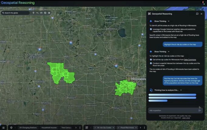
Google has introduced Geospatial Reasoning, a Gemini AI-powered tool designed to analyze environmental disasters through automated integration of diverse geospatial data. The technology enables rapid assessment of vulnerable areas and communities, reducing analysis times from years to minutes for disaster response organizations.
Core Capabilities
Geospatial Reasoning simultaneously analyzes weather patterns, satellite imagery, and population density maps to identify areas most vulnerable to disasters. The tool automates geospatial data integration, providing actionable insights for nonprofits, government agencies, and businesses focused on disaster response and infrastructure resilience. For background on geospatial technology, the Esri GIS Overview provides comprehensive context.
| Feature | Benefit |
|---|---|
| Multi-Source Data Integration | Combines weather, satellite imagery, and demographic data |
| Rapid Analysis | Reduces analysis time from years to minutes |
| Real-Time Decision Support | Enables rapid response during high-stakes scenarios |
| Vulnerability Assessment | Identifies at-risk communities and infrastructure |
Availability and Rollout
Currently available through Google‘s Trusted Tester program, Geospatial Reasoning will expand access to social impact organizations through Google.org initiatives. The technology combines Google’s geospatial expertise with Gemini AI capabilities. Additional information about Google’s AI developments is available at the Google AI website.
Early Adoption: GiveDirectly Case Study
GiveDirectly is using Geospatial Reasoning to combine flood and population data for precise humanitarian aid targeting. The organization can identify affected communities and allocate resources more efficiently than traditional assessment methods, ensuring aid reaches those most in need during disasters.
Technical Foundation
The system leverages Google’s Earth Engine infrastructure, which has provided geospatial analysis capabilities for years. Geospatial Reasoning represents a significant advancement by integrating Gemini AI’s natural language processing and pattern recognition capabilities with Earth Engine’s satellite imagery and environmental data. More details about the underlying platform are available at the Google Earth Engine website.
Applications and Use Cases
- Flood Response: Rapid identification of inundated areas and affected populations
- Wildfire Management: Real-time analysis of fire progression and evacuation planning
- Infrastructure Planning: Assessment of climate resilience for critical facilities
- Humanitarian Aid: Precision targeting of relief resources to vulnerable communities
- Early Warning Systems: Predictive analysis for disaster preparedness
Google’s Crisis Response Commitment
The launch represents Google’s ongoing investment in AI-powered crisis response tools. The company has previously deployed similar technologies during wildfires and floods, demonstrating consistent commitment to supporting emergency response organizations. According to Google’s announcement, these tools continue evolving to address increasingly complex environmental challenges.
Industry Impact: Observers note Google’s unique approach provides real-time decision support capabilities in high-stakes scenarios, representing a significant advancement over traditional geospatial analysis methods that required extensive manual data processing.
Geospatial Reasoning demonstrates how advanced AI can translate complex environmental data into actionable insights for disaster response, potentially improving outcomes for communities facing natural disasters and environmental crises.


